




















Learn and Share
Recently active
With continuing to bid on very large properties or large groups of properties, I am looking to begin using takeoffs in Aspire in 2026. I am looking for someone who is deep in knowledge on the integration between Aspire + Property Intel and who can help us set up the things we’re wanting to set up the way we want them.
Hi, Looking to hook my landscape construction estimator who handles our larger AIA billing scale jobs up with similar from another company that has been using Property Intel and Aspire for all their estimating.I you could respond with contact info it would be greatly appreciated. Thank you,
What’s New in June Take even more control of your organization’s access with more role-based permissions. Admins can further configure what each role can see and do — protecting sensitive data, preventing accidental changes, and keeping each team member focused on the right work. Project Access Control: Set roles to read-only for projects, so field staff can view takeoffs and plans without risk of accidentally modifying measurements or annotations. Template Locking: Lock master templates so only admins can modify them — even for users who normally have template editing rights. Proposal & Catalog Controls: Restrict who can create or edit proposals, modify catalog prices, and configure PI Complete feature mappings — keeping client-facing documents and pricing consistent across your team. PI Complete Ordering Tiers: New granular ordering permissions let you assign “draft only” access to some roles while reserving full submission rights for others. Set per-role credit limit
Uncover the Newest Updates in PropertyIntel Take your site audits into the field. PropertyIntel's Reference Maps now work seamlessly on mobile — place pins, edit details, manage groups, attach photos, and share views, all from your phone. • Drop Pins Instantly: Long press anywhere on the map to place a pin — no menus, no extra taps.• Full Pin Details On-Site: View and edit pin names, colors, groups, values, tags, and descriptions right from your device. • Group Management: View group details and answer prompts while you're walking the property. Attach Photos: Snap a photo or upload from your device and attach it to any pin, right from the field. Shareable Mobile Views: Send a read-only shared link that renders beautifully on any device. NEW — Enterprise Permissions (Enterprise Tier Only) Take control of who can do what in PropertyIntel. New role-based permissions let admins configure exactly which team members can create projects, manage properties, edit the catalog, and more. Cu
Discover What's New in PropertyIntel We've tightened up the ProMaps workflow so you can go from property address to AI-driven data layers faster than ever. Streamlined Flow: Simplified data pack selections have moved to the first step, parcel boundaries are now auto-highlighted, and selected packs enable themselves automatically when the flow wraps up. Time-Matched Data: Change the capture date and your ProMaps data layers update to match — so you're always analyzing data that reflects the background you're looking at. Boundary Limit Indicator: Defining an area that's too large? The boundary line turns red in real time and a banner tells you exactly how to shrink it before submitting. Reliable Boundary Editing: Click the ProMaps boundary to select it, drag vertices to reshape, or hit delete to start fresh — just like any other polygon in the app. NEW — Bulk Convert Data Layers to Catalog ItemsTake the manual work out of turning ProMap data into your takeoff. Select multiple da
High-Impact New Features are Here Our latest update introduces advanced drawing tools built to provide total precision and effortless control for every takeoff. Measurements at a GlanceToggle on Length Labels to see exact segment dimensions displayed directly on your canvas — no need to click into the properties panel. Precise Placement Set an exact length before you draw, or click any label on the canvas to type in a new value. Lines adjust instantly to match. Mirror & Flip in Seconds Select any drawing or group of drawings and flip it horizontally or vertically — perfect for symmetrical layouts without redrawing from scratch. One-Click Perimeter TracingActivate Dynamic Trace, click any existing shape's boundary, and a length measurement is automatically generated to match the full perimeter. See Before You Place A live silhouette preview follows your cursor during object placement so you can see exactly where materials will land before you commit. Group Mode for Objects Draw a
It’s release time 🏁 Here are the highlights from the February 2026 release that have everyone talking: Dynamic Fill for AreasSelect an area material, toggle on Dynamic Fill, and click once inside any contained area on your PDF — the material automatically fills within the defined lines of the plan. No more tracing boundaries manually. This feature is only available for Advanced tiers and above. Line Tool for Objects Place objects like plants, lights, or fixtures along a drawn path with automatic spacing. Select an object item, choose the line tool, draw a single or multi-segment line, and the system populates that path with your item at the spacing interval you define. The total count is automatically reflected in your material takeoff list. NEW — PI Complete Item Mapping Take the manual work out of transitioning PI Complete orders into your projects. You can now preconfigure how PI Complete features map to your PropertyIntel Templates, so materials are structured and ready the mo
Announcing the latest PropertyIntel Release This update introduces several new capabilities alongside general enhancements. We are particularly excited to debut our latest AI driven features in this version. Key highlights include: AI-Generated Item Lists from PDF Legends Instantly generate item lists from PDF legends using AI, then refine them through simple conversation. Automatic Object Placement Using Symbol Recognition Our AI-powered dynamic placement tool now automatically recognizes symbols and populates your PDF, ensuring consistency while cutting down on manual work. Snap to PDF Lines Drawing is now even easier: objects now automatically snap to PDF lines, ensuring your layouts are perfectly aligned every time. Search and Associate Text Within PDFs Quickly find exactly what you need with new in project text search for all your PDFs. Catch the full release notes here.
map design
The Latest PropertyIntel Release is Here 📪 Project Page Management We're excited to roll out several quality-of-life improvements this month focused on making project setup and plan management more flexible and intuitive. Ability to replace the page background when using PDF or Blank background Project types New click-and-drag functionality for page reordering Project Edit Permissions and Locking This release introduces new granular control over project editing, ensuring data integrity and managing access across your organization. These features are available for Advanced and above tiers. Admins now have the ability to control whether Project Edit permissions are enabled by default across the entire organization Standard users can now restrict editing access on their projects, while maintaining viewing capabilities for Admins and users that they specify Admins can access and edit any project in the organization, regardless of the individual project restriction setting to ensu
Curious how others are using PropertyIntel alongside Aspire? Let’s compare notes! Whether it’s site measurements, estimates, or project handoffs, we’d love to hear how you’re making the tools work together in your day-to-day. Your workflow tips might be the game-changer someone else is looking for. Thank you in advance for sharing.
This summer is flying by, and it sure is a hot one! Keep your customers’ properties—and your hard work on-site—looking fresh and hydrated with new irrigation systems. With PropertyIntel, creating simple irrigation layouts or zone maps is quick and easy. In this month’s PropertyIntel Power Up, product manager Joshua Martin demonstrates how to create a basic irrigation layout. As an added bonus for our Aspire users, he shows how to launch from the Aspire estimate and sync the data automatically to seamlessly generate a finalized estimate. Don’t have a PropertyIntel account? Create your free trial at aspirepropertyintel.com.
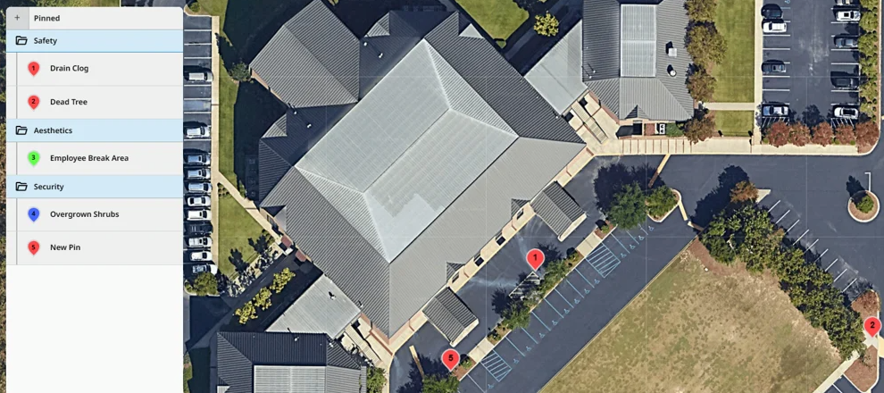
Unlock New Revenue and Increase Efficiency PropertyIntel’s powerful new Site Audit and Reference Map features and workflows are designed to help you easily identify and visualize opportunities on a property—and it’s integrated directly with the Aspire Site Audit workflow. Integrating your Aspire Site Audits with PropertyIntel’s new workflow helps you: Visualize opportunities on the map Stay organized and connected Enhance customer communication And win more work Learn more about how you can quickly populate your Aspire Site Audits on the PropertyIntel Reference Map, adjust pin locations, add more information, and create projects for new enhancement designs or takeoffs. Read all the updates here. Get a free 14 Day Trial here.
Watch the 100 Days of Hell Webinar Recording 📹 Join the PropertyIntel team in this deep-dive webinar recording to learn how PropertyIntel Complete's done-for-you measurement service helps you overcome the challenges faced during peak season. Hear from guest speaker, Katie Clark of Schill Landscaping, about her perspective on the busy season, how she uses PI Complete in her role, and the benefits she's realized through the partnership. 📎 Create your 14-day free trial for PropertyIntel here.
Anyone successfully utilized PropertyIntel on an iPad?I’d like to create irrigation maps for our properties on Property Intel so I don’t have to use a separate system but it doesn’t seem like PI really functions on Chrome on iOS.
Our Team has Been Working on a Variety of Initiatives Most notably, investing a majority of resources into Reference Maps to prepare for the upcoming Site Audits workflow. New features and improvements related to Reference Maps provide you with a significant sales advantage in those critical conversations. With easy-to-view Pins and their details, a new report, and more, your salespeople can impress your customers and increase close rates. Check out April’s release details below! NEW: Reference Maps — Preview Pin Details when hovering A new feature within Reference Maps provides you and your customers greater visibility—and fewer clicks—when viewing details associated with a Pin. Now, hovering over a Pin will display basic included details, as well as any images associated with the Pin, making it quick and easy to learn about the work planned or issue recognized at the Pin location. IMPROVED: Reference Maps — Report Builder Reference Maps can now be exported into printable reports
Busy Season Calls for A Webinar Peak season got you stressed? We invite existing PropertyIntel users to join our Power Hour webinar on April 23rd at noon EST for tips, tricks, and real-world insights to conquer the "100 Days of Hell." 📅 Date: 4/23/25⏰ Time: 12:00 PM EST 💪 Learn how to tackle the chaos with PropertyIntel Complete 💪 Click the link to sign up.
Maintenance Map Essentials Whether you’ve been measuring with PropertyIntel for years or are just getting started, it’s always worth revisiting the basics. Like a professional athlete working on their fundamentals, spending just a few minutes of your time to focus on the foundations of your day-to-day work continues to pay off for years to come. In this second edition of the PropertyIntel Power Up, Principal Product Manager Joshua Martin takes us on a deep dive into all the foundational skills needed to make the most effective maintenance maps with PropertyIntel. In this video, you'll learn: The relationship between Properties and Projects Strategically selecting services like mower size for efficient job planning and accurate estimating Advanced measuring tools, like Snap to Edges, to measure faster and create more uniform takeoffs Material associations to generate measurements for multiple services with a single shape And more
I’ve long lamented that we can’t import groups of service with their kits into opportunities. We’ve begun to use PI to work around this. We have the catalog groups set up with the kits in them in PI. Once we launch “Estimate in PropertyIntel” we can use the “+” to add a group and choose one that we’ve already made. This has been big for our pool construction teams.
🚀 Introducing PropertyIntel Power Up Your monthly guide to mastering PropertyIntel with expert insights, pro tips, and exclusive feature deep dives! Each month, we’ll feature a short video from a member of the PropertyIntel team covering a wide variety of topics like:In-depth demos of specific workflows in PropertyIntel Seasonal insights and how to overcome their challenges Tips, tricks, and expert hacks to optimize your workflowIn our first edition, Principal Product Manager Joshua Martin walks you through ProMaps, featuring AI-assisted measuring, slope visualization, and advanced measuring tools to help you bid, win, and service more jobs in less time. Unlike manual measurements or PropertyIntel Complete’s done-for-you service, ProMaps puts the power of artificial intelligence right in your hands. ProMaps is available to Advanced and Enterprise subscribers. If you’re on the Essential tier and want to try it out, reply to this post or submit a support ticket for a free two-week tri
⌛ A Look Back at 2024 ⌛ Throughout last year, PropertyIntel introduced 19 new features, addressed 77 bug requests and minor enhancements, and implemented 50 customer-suggested ideas from the idea portal. Take a look at the largest and most exciting developments we delivered to help you bid, win, and service more jobs in less time: 1. ProMaps Artificial Intelligence LaunchIn May 2024, we introduced ProMaps, marking our first foray into artificial intelligence within PropertyIntel. Allowing you to overlay new AI-generated data sources on aerial imagery like measurements by feature and slope visualization, ProMaps facilitates faster measurements, estimates, and job planning than ever before. 2. Advanced Drawing and Editing Tools and FunctionalitiesOver the course of 2024, we released thirteen new advanced drawing tools and functionalities, including the reverse cutout tool, metric units, snap-to-edges, and more! These new tools and abilities empower you to more quickly and easily create
Team, can you please help me. I inactive one route because we have 3 different but I want to merge them and add all in one only route and I inactive the other 2 routes but Im not able to see all the trips that were before. So with that said how can I merge them and how can I activate them again? thank you
Hey folks! We really need more photos in PropertyIntel to create basic landscape designs and I was wondering if anyone knows of a place or vendor where we can either download or purchase high quality photos of plants?
Trying to decide if this would be a good add on to get for our company. Some of the areas we service are rural and have quite a few trees on them. Does anyone have any insight/experience they could share with me if it has been of benefit to them?
When I click on request a demo for PropertyIntel from the Aspire knowledge base it takes me to a page to sign up for a trial for PropertyIntel. I signed up for a trial, but I would still like a demo to see how the integration works. Could someone reach out?
Already have an account? Login
No account yet? Create an account
Enter your E-mail address. We'll send you an e-mail with instructions to reset your password.